
2009, ISBN: 9780376051523
Gebundene Ausgabe
Sacramento, CA: CALIFORNIA NATIVE PLANT SOCIETY PUB. Very Good. 1994,February. Fifth Edition. paperback. 8x11" OVERSIZED. VERY GOOD CONDITION PAPERBACK, clean, sollid, bright; cover … Mehr…
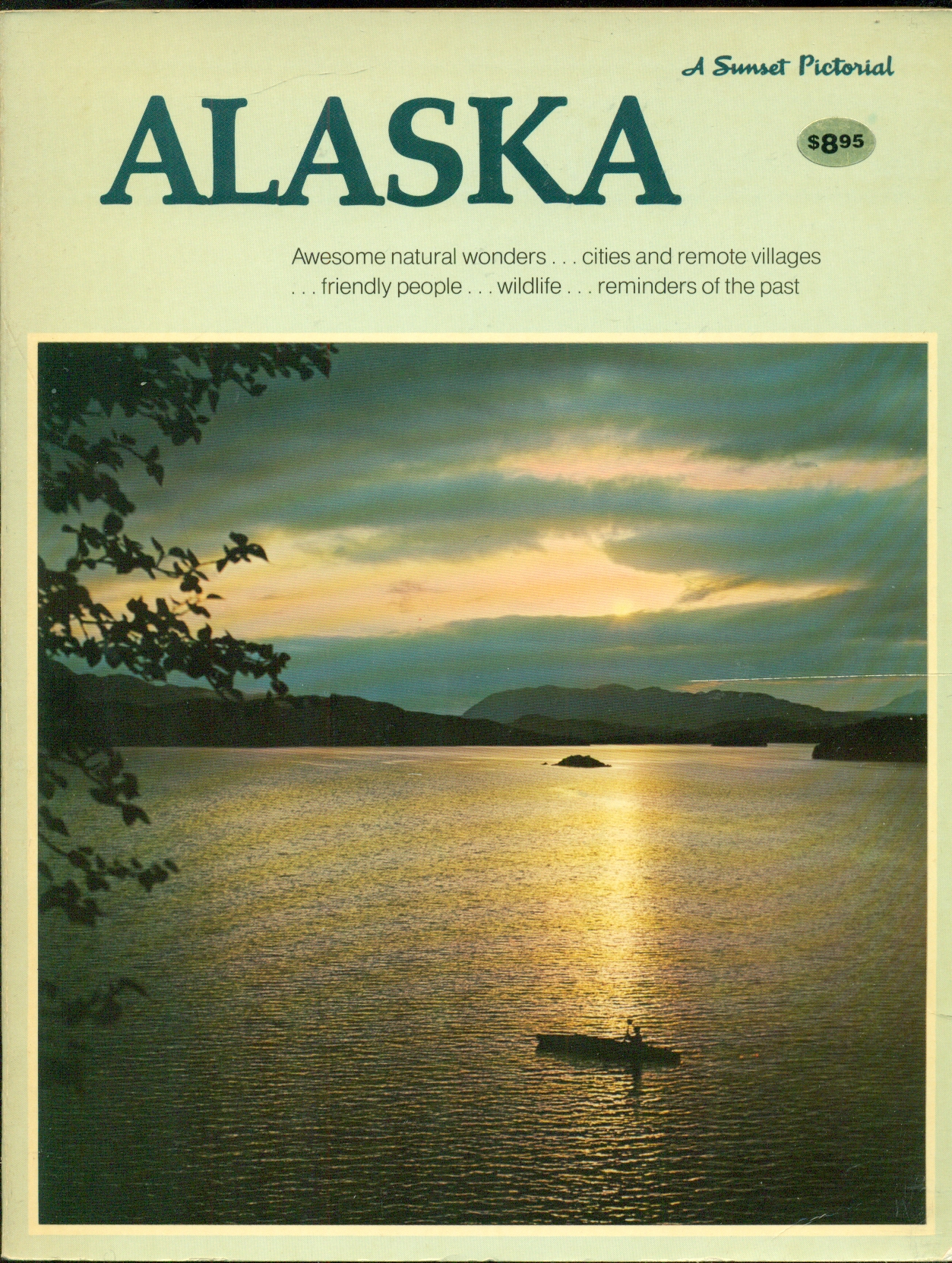
Sacramento, CA: CALIFORNIA NATIVE PLANT SOCIETY PUB. Very Good. 1994,February. Fifth Edition. paperback. 8x11" OVERSIZED. VERY GOOD CONDITION PAPERBACK, clean, sollid, bright; cover photo of yellow flowers on light peach cover with bright orange borders.. ; 338pg THICK pages; Federal, State Listings. "A complete reference for the status and distribution summaries for 1742 of California's rarest plants. Topographic quad data for more than 1200 plants and county data for all 1742 plants. This 1994 edition was completely revised and updated, more than 300 plants, added." ., CALIFORNIA NATIVE PLANT SOCIETY PUB, 1994,February, 3, United States Geological Survey. , 1988. Map. Very Good. No Binding. Two (2) large folded sheets and 10-pp. explanation of geology, economic geology, and geochemistry in printed envelope (complete for this publication); sheets include six geologic maps superposed on topographic contours showing distribution of mineral suites, description of map units, and correlation of units, and tables and graphs summarizing the geochemistry; ex-corporate library; tear on upper edge of envelope, o/w sheets and pamphlet in very good condition. ., United States Geological Survey., 1988, 3, United States Geological Survey. , 1988. Map. Very Good. No Binding. Three (3) large folded sheets in printed envelope (complete for this publication); sheets include eight geologic maps superposed on topographic contours showing distribution of element suites, description of map units, and correlation of units, and tables and graphs summarizing the geochemistry; ex-corporate library; in very good condition. ., United States Geological Survey., 1988, 3, United States Geological Survey. , 1988. Map. Very Good. No Binding. Three (3) large folded sheets in printed envelope (complete for this publication); sheets include eight geologic maps superposed on topographic contours showing distribution of mineral suites, description of map units, and correlation of units, and tables and graphs summarizing the geochemistry; ex-corporate library; in very good condition. ., United States Geological Survey., 1988, 3, Washington D.C.: Government Printing Office, 1915. colored map showing area in Utah from west of the Grouse Mountains east to the Great Salt Lake.. 1st. Unbound. Very Good. Illus. by Colored Map. 8"x 8"., Government Printing Office, 1915, 3, Washington D.C.: Government Printing Office, 1915. colored map showing area in Wyoming from West of Walcott to just east of Red Rock & Harper.. 1st. Unbound. Very Good. Illus. by Colored Map. 8" x 8"., Government Printing Office, 1915, 3, Washington D.C.: Government Printing Office, 1915. colored map showing area in Wyoming from West of Laramie to just east of Cheyenne at Fort Russell.. 1st. Unbound. Very Good. Illus. by Colored Map. 8" x 8"., Government Printing Office, 1915, 3, Menlo Park, California: Sunset Books, Inc., 1997. 416 Pages. January 1997 Edition. Laminated pictorial boards with no noted defects.Interior text pages are faultless with color photographs, drawings and boxes on every page. A companion book to the Sunset Western Garden Book. Sunset is the authority on Western Gardening for over 50 years. Contains over 600 photogrpahs and dozens of ready-to-use landscape plans. Step-by-step illustrateions and exploded views show you how teo do it yourself. This landscape book is filled with design tips and tricks from professional landscape designers, gardeners, plantsmen, and many other experts. It addresses the landscaping challenges of your region and gives you solutions. Contents in Eight Chapters: Planning Your Garden, Gardens of the West, Landscaping with Sturctures, Landscaping with Plants, Finishing Touches, Regional Problems and Sollutions, Landscape Plans, and Materials and Techniques. Large heavy book that may incur additional charges for Priority Shipping to most locations. . First Printing Stated. Hard Back. Near Fine/No Dust Jacket. 8 1/2" X 11"., Sunset Books, Inc., 1997, 4, Washington, D.C.: Government Printing Office, 1915. colored map showing area in Wyoming from Hillside to Rock Springs.. 1st. Unbound. Very Good. Illus. by Colore Map. 8" x 8"., Government Printing Office, 1915, 3, Washington D.C.: Government Printing Office, 1915. olored map showing area in Wyoming from Lahkota to Red Desert.. 1st. Unbound. Very Good. 8" x 8"., Government Printing Office, 1915, 3, Washington D.C.: Government Printing Office, 1915. colored map showing area in Wyoming from west of Devil's Slide, Utah to east of Mammoth Hollow in Wyoming.. 1st. Unbound. Very Good. Illus. by b/w Map w/red. 8" x 8"., Government Printing Office, 1915, 3, Washington D.C.: Government Printing Office, 1915. colored map showing area in Wyoming from west of Hampton to just east of Pilot Bluff & Kanda.. 1st. Unbound. Very Good. Illus. by b/w Map w/red. 8" x 8"., Government Printing Office, 1915, 3, Washington D.C.: Government Printing Office, 1915. colored map showing area in California east of Roseville to just east of Snow Mountain.. 1st. Unbound. Very Good. Illus. by b/w map with Red. 8" x 8"., Government Printing Office, 1915, 3, Washington D.C.: Government Printing Office, 1915. colored map showing area in California west of Suisun Bay to just east of Folsom & Sacramento.. 1st. Unbound. Very Good. Illus. by Colored Map. 8" x 8"., Government Printing Office, 1915, 3, U.S.A: Thunder Bay Press. Fine in Fine dust jacket. 2009. First Edition. Hardcover. 1607100037 . Very clean & tightly bound landscape format hardback book with no inscriptions, in a bright unclipped dustjacket. Appears little used. 144 pages, many colour & b/w photos in the text, index ., Thunder Bay Press, 2009, 5, Boston, Mass: Little, Brown and Company, 2001. No marks or inscriptions. No creasing to covers or to spine. A very clean very tight copy with bright unmarked boards and no bumping to corners. 200pp. A celebration of the photography of Ansel Adams with about 115 of his black & white images of the United States, mainly in California.. Soft Cover with Self-Wraps. Fine. 9.75 x 10.75 inches., Little, Brown and Company, 2001, 5, La Jolla, California: Earthwalk Press, 1999. 5th or later Edition . No Binding. As New. Ultimate maps- New Waterproof edition, 6th edition. Features: Topographic Map, Backcountry Regulations, Bear Country Hiking, Winter Information, 1988 Fires, Safety. These maps are based on USGS topographic maps that Earthwalk Press revises in cooperation with the managing agency. Basically, this is a huge foldout map with addition information on Yellowstone National Park. A very nice unused copy; available for immediate shipment, carefully packed!, Earthwalk Press, 1999, 5, Charleston, SC: Arcadia Publishing, 2006. Part of the 'Images of Aviation' series. 128 pages. Over 200 b/w photographs and other illustrations. Every book is sent in a rigid cardboard posting box.. First Edition. Paperback. Fine. 23.5 Cm x 16.5 Cm., Arcadia Publishing, 2006, 5, Graphic Arts Center Publishing Company, 1998. Book. Very Good. hardback. hardback, undated but the 7th printing of 1998, folio measuring 13 1/2" x 10", a very good tightly bound copy in a well preserved pictorial dust wrapper, bookplate of a previous owner else the text is clean and unmarked, colour photographic plates throughout, 191pp., Graphic Arts Center Publishing Company, 1998, 3, United States Government Printing Office., 1913. Book. Good. Soft cover. ORIGINAL 1913 PUBLICATION; softcover; ex-library; small chip on fore-edge of rear cover; light tanning of leaves; spine reinforced w/ tape; o/w in good condition.., United States Government Printing Office., 1913, 2.5, Menlo Park, California: Lane Publishing Co., 1982. 208 Pages Indexed. This is the June 1982 First Edition and Sixth Printing. This book is A Sunset Pictorial with black and white and many color photographs. Contents: A Beckoning Frontier, The Southeast's Panhandle, The Vast Interior. The Southcentral Region, The Southwestern Corner, Eskimo Alaska, and Selected Readings. Alaska has wilderness, wildlife, fishing, glaciers, tundra. It has old Russian churches, Eskimo villages, fiords, totem poles, permafrost, northern lights, and midnight sun. It is so vast that it is difficult to comprehend its size. The big states of Texas, California, and Montana combined would fit easily in its 586,400 square miles. If a map of Alaska were superimposed on a map of the rest of the United States mainland, it would blanket the central part of the country from the Canadian border to Arkansas and from Indiana to Colorado. Its southeastern corner would reach to the Atlantic Coast, and its Aleutian Islands would extend beyond the Pacific Coast. It is not surprising that in so huge an area there are regions that differ distinctly-in climate, scenery, people, topography, and economy. Alaska divides naturally into six such regions: Southeastern Alaska, often referred to as "the Panhandle"; the Interior, bounded by the Alaska Range on the south and the Brooks Range on the north; the Southcentral region, rimming the Gulf of Alaska south of the Alaska Range; Southwestern Alaska, extending from the Alaska Peninsula to the tip of the Aleutian Islands; the Western coastal area, bordering the Bering Sea; and the Arctic, above the Arctic Circle. Southeastern Alaska is a tourist's paradise, made up of several large islands, hundreds of smaller ones, and a thin strip of rugged mainland bordering Canada. Jagged mountains rise from picturesque fiords along the protected waterway called the Inside Passage, and glaciers reach to the water's edge. Most of the Southeast is part of Tongass National Forest. Massive stands of spruce, hemlock, and cedar cover the islands and much of the mainland. Juneau, Alaska's capital, hugs the mountains near the northern end of the waterway. Most of the other Panhandle towns are engaged in fishing and lumbering activities. . First Edition Stated. Trade Paperback. Near Fine. Illus. by Cole. Dick- Cartography and Illustrations. 8 1/2" X 11"., Lane Publishing Co., 1982, 4<
| usa, u.. | Biblio.co.uk Wonderful Books by Mail, Eryops Books, Eryops Books, Eryops Books, Dorley House Books, Dorley House Books, Dorley House Books, Dons Book Store, Dorley House Books, Dorley House Books, Dorley House Books, Dorley House Books, Dorley House Books, Dorley House Books, Aucott & Thomas, Godley Books, James Lasseter, Jr., Peter White Books, Pendleburys - the bookshop in the hills, Eryops Books, Dons Book Store Versandkosten: EUR 18.62 Details... |
2009, ISBN: 9780376051523
Gebundene Ausgabe
Sacramento, CA: CALIFORNIA NATIVE PLANT SOCIETY PUB. Very Good. 1994,February. Fifth Edition. paperback. 8x11" OVERSIZED. VERY GOOD CONDITION PAPERBACK, clean, sollid, bright; cover … Mehr…
Sacramento, CA: CALIFORNIA NATIVE PLANT SOCIETY PUB. Very Good. 1994,February. Fifth Edition. paperback. 8x11" OVERSIZED. VERY GOOD CONDITION PAPERBACK, clean, sollid, bright; cover photo of yellow flowers on light peach cover with bright orange borders.. ; 338pg THICK pages; Federal, State Listings. "A complete reference for the status and distribution summaries for 1742 of California's rarest plants. Topographic quad data for more than 1200 plants and county data for all 1742 plants. This 1994 edition was completely revised and updated, more than 300 plants, added." ., CALIFORNIA NATIVE PLANT SOCIETY PUB, 1994,February, 3, United States Geological Survey. , 1988. Map. Very Good. No Binding. Three (3) large folded sheets in printed envelope (complete for this publication); sheets include eight geologic maps superposed on topographic contours showing distribution of mineral suites, description of map units, and correlation of units, and tables and graphs summarizing the geochemistry; ex-corporate library; in very good condition. ., United States Geological Survey., 1988, 3, United States Geological Survey. , 1988. Map. Very Good. No Binding. Two (2) large folded sheets and 10-pp. explanation of geology, economic geology, and geochemistry in printed envelope (complete for this publication); sheets include six geologic maps superposed on topographic contours showing distribution of mineral suites, description of map units, and correlation of units, and tables and graphs summarizing the geochemistry; ex-corporate library; tear on upper edge of envelope, o/w sheets and pamphlet in very good condition. ., United States Geological Survey., 1988, 3, United States Geological Survey. , 1988. Map. Very Good. No Binding. Three (3) large folded sheets in printed envelope (complete for this publication); sheets include eight geologic maps superposed on topographic contours showing distribution of element suites, description of map units, and correlation of units, and tables and graphs summarizing the geochemistry; ex-corporate library; in very good condition. ., United States Geological Survey., 1988, 3, Washington, D.C.: Government Printing Office, 1915. colored map showing area in Wyoming from Hillside to Rock Springs.. 1st. Unbound. Very Good. Illus. by Colore Map. 8" x 8"., Government Printing Office, 1915, 3, Washington D.C.: Government Printing Office, 1915. olored map showing area in Wyoming from Lahkota to Red Desert.. 1st. Unbound. Very Good. 8" x 8"., Government Printing Office, 1915, 3, Washington D.C.: Government Printing Office, 1915. colored map showing area in Wyoming from west of Devil's Slide, Utah to east of Mammoth Hollow in Wyoming.. 1st. Unbound. Very Good. Illus. by b/w Map w/red. 8" x 8"., Government Printing Office, 1915, 3, Washington D.C.: Government Printing Office, 1915. colored map showing area in Wyoming from west of Hampton to just east of Pilot Bluff & Kanda.. 1st. Unbound. Very Good. Illus. by b/w Map w/red. 8" x 8"., Government Printing Office, 1915, 3, Washington D.C.: Government Printing Office, 1915. colored map showing area in California east of Roseville to just east of Snow Mountain.. 1st. Unbound. Very Good. Illus. by b/w map with Red. 8" x 8"., Government Printing Office, 1915, 3, Washington D.C.: Government Printing Office, 1915. colored map showing area in California west of Suisun Bay to just east of Folsom & Sacramento.. 1st. Unbound. Very Good. Illus. by Colored Map. 8" x 8"., Government Printing Office, 1915, 3, Washington D.C.: Government Printing Office, 1915. colored map showing area in Utah from west of the Grouse Mountains east to the Great Salt Lake.. 1st. Unbound. Very Good. Illus. by Colored Map. 8"x 8"., Government Printing Office, 1915, 3, Washington D.C.: Government Printing Office, 1915. colored map showing area in Wyoming from West of Walcott to just east of Red Rock & Harper.. 1st. Unbound. Very Good. Illus. by Colored Map. 8" x 8"., Government Printing Office, 1915, 3, Washington D.C.: Government Printing Office, 1915. colored map showing area in Wyoming from West of Laramie to just east of Cheyenne at Fort Russell.. 1st. Unbound. Very Good. Illus. by Colored Map. 8" x 8"., Government Printing Office, 1915, 3, Menlo Park, California: Sunset Books, Inc., 1997. 416 Pages. January 1997 Edition. Laminated pictorial boards with no noted defects.Interior text pages are faultless with color photographs, drawings and boxes on every page. A companion book to the Sunset Western Garden Book. Sunset is the authority on Western Gardening for over 50 years. Contains over 600 photogrpahs and dozens of ready-to-use landscape plans. Step-by-step illustrateions and exploded views show you how teo do it yourself. This landscape book is filled with design tips and tricks from professional landscape designers, gardeners, plantsmen, and many other experts. It addresses the landscaping challenges of your region and gives you solutions. Contents in Eight Chapters: Planning Your Garden, Gardens of the West, Landscaping with Sturctures, Landscaping with Plants, Finishing Touches, Regional Problems and Sollutions, Landscape Plans, and Materials and Techniques. Large heavy book that may incur additional charges for Priority Shipping to most locations. . First Printing Stated. Hard Back. Near Fine/No Dust Jacket. 8 1/2" X 11"., Sunset Books, Inc., 1997, 4, U.S.A: Thunder Bay Press. Fine in Fine dust jacket. 2009. First Edition. Hardcover. 1607100037 . Very clean & tightly bound landscape format hardback book with no inscriptions, in a bright unclipped dustjacket. Appears little used. 144 pages, many colour & b/w photos in the text, index ., Thunder Bay Press, 2009, 5, Boston, Mass: Little, Brown and Company, 2001. No marks or inscriptions. No creasing to covers or to spine. A very clean very tight copy with bright unmarked boards and no bumping to corners. 200pp. A celebration of the photography of Ansel Adams with about 115 of his black & white images of the United States, mainly in California.. Soft Cover with Self-Wraps. Fine. 9.75 x 10.75 inches., Little, Brown and Company, 2001, 5, La Jolla, California: Earthwalk Press, 1999. 5th or later Edition . No Binding. As New. Ultimate maps- New Waterproof edition, 6th edition. Features: Topographic Map, Backcountry Regulations, Bear Country Hiking, Winter Information, 1988 Fires, Safety. These maps are based on USGS topographic maps that Earthwalk Press revises in cooperation with the managing agency. Basically, this is a huge foldout map with addition information on Yellowstone National Park. A very nice unused copy; available for immediate shipment, carefully packed!, Earthwalk Press, 1999, 5, Charleston, SC: Arcadia Publishing, 2006. Part of the 'Images of Aviation' series. 128 pages. Over 200 b/w photographs and other illustrations. Every book is sent in a rigid cardboard posting box.. First Edition. Paperback. Fine. 23.5 Cm x 16.5 Cm., Arcadia Publishing, 2006, 5, Graphic Arts Center Publishing Company, 1998. Book. Very Good. hardback. hardback, undated but the 7th printing of 1998, folio measuring 13 1/2" x 10", a very good tightly bound copy in a well preserved pictorial dust wrapper, bookplate of a previous owner else the text is clean and unmarked, colour photographic plates throughout, 191pp., Graphic Arts Center Publishing Company, 1998, 3, United States Government Printing Office., 1913. Book. Good. Soft cover. ORIGINAL 1913 PUBLICATION; softcover; ex-library; small chip on fore-edge of rear cover; light tanning of leaves; spine reinforced w/ tape; o/w in good condition.., United States Government Printing Office., 1913, 2.5, Menlo Park, California: Lane Publishing Co., 1982. 208 Pages Indexed. This is the June 1982 First Edition and Sixth Printing. This book is A Sunset Pictorial with black and white and many color photographs. Contents: A Beckoning Frontier, The Southeast's Panhandle, The Vast Interior. The Southcentral Region, The Southwestern Corner, Eskimo Alaska, and Selected Readings. Alaska has wilderness, wildlife, fishing, glaciers, tundra. It has old Russian churches, Eskimo villages, fiords, totem poles, permafrost, northern lights, and midnight sun. It is so vast that it is difficult to comprehend its size. The big states of Texas, California, and Montana combined would fit easily in its 586,400 square miles. If a map of Alaska were superimposed on a map of the rest of the United States mainland, it would blanket the central part of the country from the Canadian border to Arkansas and from Indiana to Colorado. Its southeastern corner would reach to the Atlantic Coast, and its Aleutian Islands would extend beyond the Pacific Coast. It is not surprising that in so huge an area there are regions that differ distinctly-in climate, scenery, people, topography, and economy. Alaska divides naturally into six such regions: Southeastern Alaska, often referred to as "the Panhandle"; the Interior, bounded by the Alaska Range on the south and the Brooks Range on the north; the Southcentral region, rimming the Gulf of Alaska south of the Alaska Range; Southwestern Alaska, extending from the Alaska Peninsula to the tip of the Aleutian Islands; the Western coastal area, bordering the Bering Sea; and the Arctic, above the Arctic Circle. Southeastern Alaska is a tourist's paradise, made up of several large islands, hundreds of smaller ones, and a thin strip of rugged mainland bordering Canada. Jagged mountains rise from picturesque fiords along the protected waterway called the Inside Passage, and glaciers reach to the water's edge. Most of the Southeast is part of Tongass National Forest. Massive stands of spruce, hemlock, and cedar cover the islands and much of the mainland. Juneau, Alaska's capital, hugs the mountains near the northern end of the waterway. Most of the other Panhandle towns are engaged in fishing and lumbering activities. . First Edition Stated. Trade Paperback. Near Fine. Illus. by Cole. Dick- Cartography and Illustrations. 8 1/2" X 11"., Lane Publishing Co., 1982, 4<
| usa, u.. | Biblio.co.uk Wonderful Books by Mail, Eryops Books, Eryops Books, Eryops Books, Dorley House Books, Dorley House Books, Dorley House Books, Dorley House Books, Dorley House Books, Dorley House Books, Dorley House Books, Dorley House Books, Dorley House Books, Dons Book Store, Aucott & Thomas, Godley Books, James Lasseter, Jr., Peter White Books, Pendleburys - the bookshop in the hills, Eryops Books, Dons Book Store Versandkosten: EUR 18.46 Details... |
2009, ISBN: 9780376051523
Ballantine Books, 1996-05-28. Paperback. Good. Prompt shipment, with tracking. we ship in CLEAN SECURE NEW boxes Good paperback, creased spine. Marginalia in pages, heavy marginali… Mehr…
Ballantine Books, 1996-05-28. Paperback. Good. Prompt shipment, with tracking. we ship in CLEAN SECURE NEW boxes Good paperback, creased spine. Marginalia in pages, heavy marginalia on inside back cover, rear pages. Light foxing to edges., Ballantine Books, 1996-05-28, 2.5, [Annapolis]: Maryland State Archives, 2009. First printing. Softcover. Quarto. [ii], 46 pages. New. Well illustrated in color and black and white. The only detailed account of Abraham Lincoln's passage through Annapolis on his way to and from the Hampton Roads Conference in early February, 1865. <br /> <br /> The extensive research for this project turned up interesting but forgotten aspects of local and national history. For example, the Maryland Legislature was debating ratification of the 13th Amendment to abolish slavery on the very morning that President Lincoln quietly walked past the State House, unbeknownst to the legislators inside. The amendment had passed Congress two days earlier on January 31st, and had been hand-delivered to the Maryland Legislature on February 1st. <br /> <br /> Research also rediscovered both the proper location of the train depot in 1865 as well as the route of the military railroad tracks hastily laid through town by General Benjamin Butler in April of 1861, over which passed the first troops to reach and reinforce Washington in those tense early days of the war.<br /> <br /> Well illustrated with historic photographs, documents, prints, and maps., Maryland State Archives, 2009, 6, Menlo Park, California: Lane Publishing Co., 1982. First Edition Stated . Trade Paperback. Very Good. 8 1/2" X 11. Cole. Dick- Cartography and Illustrations. 208 Pages Indexed. This is the June 1982 First Edition and Sixth Printing. This book is A Sunset Pictorial with black and white and many color photographs. Contents: A Beckoning Frontier, The Southeast's Panhandle, The Vast Interior. The Southcentral Region, The Southwestern Corner, Eskimo Alaska, and Selected Readings. Alaska has wilderness, wildlife, fishing, glaciers, tundra. It has old Russian churches, Eskimo villages, fiords, totem poles, permafrost, northern lights, and midnight sun. It is so vast that it is difficult to comprehend its size. The big states of Texas, California, and Montana combined would fit easily in its 586,400 square miles. If a map of Alaska were superimposed on a map of the rest of the United States mainland, it would blanket the central part of the country from the Canadian border to Arkansas and from Indiana to Colorado. Its southeastern corner would reach to the Atlantic Coast, and its Aleutian Islands would extend beyond the Pacific Coast. It is not surprising that in so huge an area there are regions that differ distinctly-in climate, scenery, people, topography, and economy. Alaska divides naturally into six such regions: Southeastern Alaska, often referred to as "the Panhandle"; the Interior, bounded by the Alaska Range on the south and the Brooks Range on the north; the Southcentral region, rimming the Gulf of Alaska south of the Alaska Range; Southwestern Alaska, extending from the Alaska Peninsula to the tip of the Aleutian Islands; the Western coastal area, bordering the Bering Sea; and the Arctic, above the Arctic Circle. Southeastern Alaska is a tourist's paradise, made up of several large islands, hundreds of smaller ones, and a thin strip of rugged mainland bordering Canada. Jagged mountains rise from picturesque fiords along the protected waterway called the Inside Passage, and glaciers reach to the water's edge. Most of the Southeast is part of Tongass National Forest. Massive stands of spruce, hemlock, and cedar cover the islands and much of the mainland. Juneau, Alaska's capital, hugs the mountains near the northern end of the waterway. Most of the other Panhandle towns are engaged in fishing and lumbering activities., Lane Publishing Co., 1982, 3<
| usa, u.. | Biblio.co.uk Robinson Street Books, IOBA, Back Creek Books LLC, ABAA/ILAB, Dons Book Store Versandkosten: EUR 4.50 Details... |
2009, ISBN: 9780376051523
Gebundene Ausgabe
U.S.A: Thunder Bay Press. Fine in Fine dust jacket. 2009. First Edition. Hardcover. 1607100037 . Very clean & tightly bound landscape format hardback book with no inscriptions, in a … Mehr…
U.S.A: Thunder Bay Press. Fine in Fine dust jacket. 2009. First Edition. Hardcover. 1607100037 . Very clean & tightly bound landscape format hardback book with no inscriptions, in a bright unclipped dustjacket. Appears little used. 144 pages, many colour & b/w photos in the text, index ., Thunder Bay Press, 2009, 5, Charleston, SC: Arcadia Publishing, 2006. Part of the 'Images of Aviation' series. 128 pages. Over 200 b/w photographs and other illustrations. Every book is sent in a rigid cardboard posting box.. First Edition. Paperback. Fine. 23.5 Cm x 16.5 Cm., Arcadia Publishing, 2006, 5, United States Government Printing Office., 1913. Book. Good. Soft cover. ORIGINAL 1913 PUBLICATION; softcover; ex-library; small chip on fore-edge of rear cover; light tanning of leaves; spine reinforced w/ tape; o/w in good condition.., United States Government Printing Office., 1913, 2.5, Menlo Park, California: Lane Publishing Co., 1982. 208 Pages Indexed. This is the June 1982 First Edition and Sixth Printing. This book is A Sunset Pictorial with black and white and many color photographs. Contents: A Beckoning Frontier, The Southeast's Panhandle, The Vast Interior. The Southcentral Region, The Southwestern Corner, Eskimo Alaska, and Selected Readings. Alaska has wilderness, wildlife, fishing, glaciers, tundra. It has old Russian churches, Eskimo villages, fiords, totem poles, permafrost, northern lights, and midnight sun. It is so vast that it is difficult to comprehend its size. The big states of Texas, California, and Montana combined would fit easily in its 586,400 square miles. If a map of Alaska were superimposed on a map of the rest of the United States mainland, it would blanket the central part of the country from the Canadian border to Arkansas and from Indiana to Colorado. Its southeastern corner would reach to the Atlantic Coast, and its Aleutian Islands would extend beyond the Pacific Coast. It is not surprising that in so huge an area there are regions that differ distinctly-in climate, scenery, people, topography, and economy. Alaska divides naturally into six such regions: Southeastern Alaska, often referred to as "the Panhandle"; the Interior, bounded by the Alaska Range on the south and the Brooks Range on the north; the Southcentral region, rimming the Gulf of Alaska south of the Alaska Range; Southwestern Alaska, extending from the Alaska Peninsula to the tip of the Aleutian Islands; the Western coastal area, bordering the Bering Sea; and the Arctic, above the Arctic Circle. Southeastern Alaska is a tourist's paradise, made up of several large islands, hundreds of smaller ones, and a thin strip of rugged mainland bordering Canada. Jagged mountains rise from picturesque fiords along the protected waterway called the Inside Passage, and glaciers reach to the water's edge. Most of the Southeast is part of Tongass National Forest. Massive stands of spruce, hemlock, and cedar cover the islands and much of the mainland. Juneau, Alaska's capital, hugs the mountains near the northern end of the waterway. Most of the other Panhandle towns are engaged in fishing and lumbering activities. . First Edition Stated. Trade Paperback. Near Fine. Illus. by Cole. Dick- Cartography and Illustrations. 8 1/2" X 11"., Lane Publishing Co., 1982, 4<
| gbr, g.. | Biblio.co.uk |

1982, ISBN: 0376051523
Taschenbuch
[EAN: 9780376051523], Gebraucht, sehr guter Zustand, [PU: Lane Publishing Co., Menlo Park, California], 208 Pages Indexed. This is the June 1982 First Edition and Sixth Printing. This boo… Mehr…
[EAN: 9780376051523], Gebraucht, sehr guter Zustand, [PU: Lane Publishing Co., Menlo Park, California], 208 Pages Indexed. This is the June 1982 First Edition and Sixth Printing. This book is A Sunset Pictorial with black and white and many color photographs. Contents: A Beckoning Frontier, The Southeast's Panhandle, The Vast Interior. The Southcentral Region, The Southwestern Corner, Eskimo Alaska, and Selected Readings. Alaska has wilderness, wildlife, fishing, glaciers, tundra. It has old Russian churches, Eskimo villages, fiords, totem poles, permafrost, northern lights, and midnight sun. It is so vast that it is difficult to comprehend its size. The big states of Texas, California, and Montana combined would fit easily in its 586,400 square miles. If a map of Alaska were superimposed on a map of the rest of the United States mainland, it would blanket the central part of the country from the Canadian border to Arkansas and from Indiana to Colorado. Its southeastern corner would reach to the Atlantic Coast, and its Aleutian Islands would extend beyond the Pacific Coast. It is not surprising that in so huge an area there are regions that differ distinctly-in climate, scenery, people, topography, and economy. Alaska divides naturally into six such regions: Southeastern Alaska, often referred to as "the Panhandle"; the Interior, bounded by the Alaska Range on the south and the Brooks Range on the north; the Southcentral region, rimming the Gulf of Alaska south of the Alaska Range; Southwestern Alaska, extending from the Alaska Peninsula to the tip of the Aleutian Islands; the Western coastal area, bordering the Bering Sea; and the Arctic, above the Arctic Circle. Southeastern Alaska is a tourist's paradise, made up of several large islands, hundreds of smaller ones, and a thin strip of rugged mainland bordering Canada. Jagged mountains rise from picturesque fiords along the protected waterway called the Inside Passage, and glaciers reach to the water's edge. Most of the Southeast is part of Tongass National Forest. Massive stands of spruce, hemlock, and cedar cover the islands and much of the mainland. Juneau, Alaska's capital, hugs the mountains near the northern end of the waterway. Most of the other Panhandle towns are engaged in fishing and lumbering activities., Books<
| AbeBooks.de Don's Book Store, Albuquerque, NM, U.S.A. [262057] [Rating: 5 (von 5)] NOT NEW BOOK. Versandkosten: EUR 4.75 Details... |

2009, ISBN: 9780376051523
Gebundene Ausgabe
Sacramento, CA: CALIFORNIA NATIVE PLANT SOCIETY PUB. Very Good. 1994,February. Fifth Edition. paperback. 8x11" OVERSIZED. VERY GOOD CONDITION PAPERBACK, clean, sollid, bright; cover … Mehr…
Sacramento, CA: CALIFORNIA NATIVE PLANT SOCIETY PUB. Very Good. 1994,February. Fifth Edition. paperback. 8x11" OVERSIZED. VERY GOOD CONDITION PAPERBACK, clean, sollid, bright; cover photo of yellow flowers on light peach cover with bright orange borders.. ; 338pg THICK pages; Federal, State Listings. "A complete reference for the status and distribution summaries for 1742 of California's rarest plants. Topographic quad data for more than 1200 plants and county data for all 1742 plants. This 1994 edition was completely revised and updated, more than 300 plants, added." ., CALIFORNIA NATIVE PLANT SOCIETY PUB, 1994,February, 3, United States Geological Survey. , 1988. Map. Very Good. No Binding. Two (2) large folded sheets and 10-pp. explanation of geology, economic geology, and geochemistry in printed envelope (complete for this publication); sheets include six geologic maps superposed on topographic contours showing distribution of mineral suites, description of map units, and correlation of units, and tables and graphs summarizing the geochemistry; ex-corporate library; tear on upper edge of envelope, o/w sheets and pamphlet in very good condition. ., United States Geological Survey., 1988, 3, United States Geological Survey. , 1988. Map. Very Good. No Binding. Three (3) large folded sheets in printed envelope (complete for this publication); sheets include eight geologic maps superposed on topographic contours showing distribution of element suites, description of map units, and correlation of units, and tables and graphs summarizing the geochemistry; ex-corporate library; in very good condition. ., United States Geological Survey., 1988, 3, United States Geological Survey. , 1988. Map. Very Good. No Binding. Three (3) large folded sheets in printed envelope (complete for this publication); sheets include eight geologic maps superposed on topographic contours showing distribution of mineral suites, description of map units, and correlation of units, and tables and graphs summarizing the geochemistry; ex-corporate library; in very good condition. ., United States Geological Survey., 1988, 3, Washington D.C.: Government Printing Office, 1915. colored map showing area in Utah from west of the Grouse Mountains east to the Great Salt Lake.. 1st. Unbound. Very Good. Illus. by Colored Map. 8"x 8"., Government Printing Office, 1915, 3, Washington D.C.: Government Printing Office, 1915. colored map showing area in Wyoming from West of Walcott to just east of Red Rock & Harper.. 1st. Unbound. Very Good. Illus. by Colored Map. 8" x 8"., Government Printing Office, 1915, 3, Washington D.C.: Government Printing Office, 1915. colored map showing area in Wyoming from West of Laramie to just east of Cheyenne at Fort Russell.. 1st. Unbound. Very Good. Illus. by Colored Map. 8" x 8"., Government Printing Office, 1915, 3, Menlo Park, California: Sunset Books, Inc., 1997. 416 Pages. January 1997 Edition. Laminated pictorial boards with no noted defects.Interior text pages are faultless with color photographs, drawings and boxes on every page. A companion book to the Sunset Western Garden Book. Sunset is the authority on Western Gardening for over 50 years. Contains over 600 photogrpahs and dozens of ready-to-use landscape plans. Step-by-step illustrateions and exploded views show you how teo do it yourself. This landscape book is filled with design tips and tricks from professional landscape designers, gardeners, plantsmen, and many other experts. It addresses the landscaping challenges of your region and gives you solutions. Contents in Eight Chapters: Planning Your Garden, Gardens of the West, Landscaping with Sturctures, Landscaping with Plants, Finishing Touches, Regional Problems and Sollutions, Landscape Plans, and Materials and Techniques. Large heavy book that may incur additional charges for Priority Shipping to most locations. . First Printing Stated. Hard Back. Near Fine/No Dust Jacket. 8 1/2" X 11"., Sunset Books, Inc., 1997, 4, Washington, D.C.: Government Printing Office, 1915. colored map showing area in Wyoming from Hillside to Rock Springs.. 1st. Unbound. Very Good. Illus. by Colore Map. 8" x 8"., Government Printing Office, 1915, 3, Washington D.C.: Government Printing Office, 1915. olored map showing area in Wyoming from Lahkota to Red Desert.. 1st. Unbound. Very Good. 8" x 8"., Government Printing Office, 1915, 3, Washington D.C.: Government Printing Office, 1915. colored map showing area in Wyoming from west of Devil's Slide, Utah to east of Mammoth Hollow in Wyoming.. 1st. Unbound. Very Good. Illus. by b/w Map w/red. 8" x 8"., Government Printing Office, 1915, 3, Washington D.C.: Government Printing Office, 1915. colored map showing area in Wyoming from west of Hampton to just east of Pilot Bluff & Kanda.. 1st. Unbound. Very Good. Illus. by b/w Map w/red. 8" x 8"., Government Printing Office, 1915, 3, Washington D.C.: Government Printing Office, 1915. colored map showing area in California east of Roseville to just east of Snow Mountain.. 1st. Unbound. Very Good. Illus. by b/w map with Red. 8" x 8"., Government Printing Office, 1915, 3, Washington D.C.: Government Printing Office, 1915. colored map showing area in California west of Suisun Bay to just east of Folsom & Sacramento.. 1st. Unbound. Very Good. Illus. by Colored Map. 8" x 8"., Government Printing Office, 1915, 3, U.S.A: Thunder Bay Press. Fine in Fine dust jacket. 2009. First Edition. Hardcover. 1607100037 . Very clean & tightly bound landscape format hardback book with no inscriptions, in a bright unclipped dustjacket. Appears little used. 144 pages, many colour & b/w photos in the text, index ., Thunder Bay Press, 2009, 5, Boston, Mass: Little, Brown and Company, 2001. No marks or inscriptions. No creasing to covers or to spine. A very clean very tight copy with bright unmarked boards and no bumping to corners. 200pp. A celebration of the photography of Ansel Adams with about 115 of his black & white images of the United States, mainly in California.. Soft Cover with Self-Wraps. Fine. 9.75 x 10.75 inches., Little, Brown and Company, 2001, 5, La Jolla, California: Earthwalk Press, 1999. 5th or later Edition . No Binding. As New. Ultimate maps- New Waterproof edition, 6th edition. Features: Topographic Map, Backcountry Regulations, Bear Country Hiking, Winter Information, 1988 Fires, Safety. These maps are based on USGS topographic maps that Earthwalk Press revises in cooperation with the managing agency. Basically, this is a huge foldout map with addition information on Yellowstone National Park. A very nice unused copy; available for immediate shipment, carefully packed!, Earthwalk Press, 1999, 5, Charleston, SC: Arcadia Publishing, 2006. Part of the 'Images of Aviation' series. 128 pages. Over 200 b/w photographs and other illustrations. Every book is sent in a rigid cardboard posting box.. First Edition. Paperback. Fine. 23.5 Cm x 16.5 Cm., Arcadia Publishing, 2006, 5, Graphic Arts Center Publishing Company, 1998. Book. Very Good. hardback. hardback, undated but the 7th printing of 1998, folio measuring 13 1/2" x 10", a very good tightly bound copy in a well preserved pictorial dust wrapper, bookplate of a previous owner else the text is clean and unmarked, colour photographic plates throughout, 191pp., Graphic Arts Center Publishing Company, 1998, 3, United States Government Printing Office., 1913. Book. Good. Soft cover. ORIGINAL 1913 PUBLICATION; softcover; ex-library; small chip on fore-edge of rear cover; light tanning of leaves; spine reinforced w/ tape; o/w in good condition.., United States Government Printing Office., 1913, 2.5, Menlo Park, California: Lane Publishing Co., 1982. 208 Pages Indexed. This is the June 1982 First Edition and Sixth Printing. This book is A Sunset Pictorial with black and white and many color photographs. Contents: A Beckoning Frontier, The Southeast's Panhandle, The Vast Interior. The Southcentral Region, The Southwestern Corner, Eskimo Alaska, and Selected Readings. Alaska has wilderness, wildlife, fishing, glaciers, tundra. It has old Russian churches, Eskimo villages, fiords, totem poles, permafrost, northern lights, and midnight sun. It is so vast that it is difficult to comprehend its size. The big states of Texas, California, and Montana combined would fit easily in its 586,400 square miles. If a map of Alaska were superimposed on a map of the rest of the United States mainland, it would blanket the central part of the country from the Canadian border to Arkansas and from Indiana to Colorado. Its southeastern corner would reach to the Atlantic Coast, and its Aleutian Islands would extend beyond the Pacific Coast. It is not surprising that in so huge an area there are regions that differ distinctly-in climate, scenery, people, topography, and economy. Alaska divides naturally into six such regions: Southeastern Alaska, often referred to as "the Panhandle"; the Interior, bounded by the Alaska Range on the south and the Brooks Range on the north; the Southcentral region, rimming the Gulf of Alaska south of the Alaska Range; Southwestern Alaska, extending from the Alaska Peninsula to the tip of the Aleutian Islands; the Western coastal area, bordering the Bering Sea; and the Arctic, above the Arctic Circle. Southeastern Alaska is a tourist's paradise, made up of several large islands, hundreds of smaller ones, and a thin strip of rugged mainland bordering Canada. Jagged mountains rise from picturesque fiords along the protected waterway called the Inside Passage, and glaciers reach to the water's edge. Most of the Southeast is part of Tongass National Forest. Massive stands of spruce, hemlock, and cedar cover the islands and much of the mainland. Juneau, Alaska's capital, hugs the mountains near the northern end of the waterway. Most of the other Panhandle towns are engaged in fishing and lumbering activities. . First Edition Stated. Trade Paperback. Near Fine. Illus. by Cole. Dick- Cartography and Illustrations. 8 1/2" X 11"., Lane Publishing Co., 1982, 4<
2009, ISBN: 9780376051523
Gebundene Ausgabe
Sacramento, CA: CALIFORNIA NATIVE PLANT SOCIETY PUB. Very Good. 1994,February. Fifth Edition. paperback. 8x11" OVERSIZED. VERY GOOD CONDITION PAPERBACK, clean, sollid, bright; cover … Mehr…
Sacramento, CA: CALIFORNIA NATIVE PLANT SOCIETY PUB. Very Good. 1994,February. Fifth Edition. paperback. 8x11" OVERSIZED. VERY GOOD CONDITION PAPERBACK, clean, sollid, bright; cover photo of yellow flowers on light peach cover with bright orange borders.. ; 338pg THICK pages; Federal, State Listings. "A complete reference for the status and distribution summaries for 1742 of California's rarest plants. Topographic quad data for more than 1200 plants and county data for all 1742 plants. This 1994 edition was completely revised and updated, more than 300 plants, added." ., CALIFORNIA NATIVE PLANT SOCIETY PUB, 1994,February, 3, United States Geological Survey. , 1988. Map. Very Good. No Binding. Three (3) large folded sheets in printed envelope (complete for this publication); sheets include eight geologic maps superposed on topographic contours showing distribution of mineral suites, description of map units, and correlation of units, and tables and graphs summarizing the geochemistry; ex-corporate library; in very good condition. ., United States Geological Survey., 1988, 3, United States Geological Survey. , 1988. Map. Very Good. No Binding. Two (2) large folded sheets and 10-pp. explanation of geology, economic geology, and geochemistry in printed envelope (complete for this publication); sheets include six geologic maps superposed on topographic contours showing distribution of mineral suites, description of map units, and correlation of units, and tables and graphs summarizing the geochemistry; ex-corporate library; tear on upper edge of envelope, o/w sheets and pamphlet in very good condition. ., United States Geological Survey., 1988, 3, United States Geological Survey. , 1988. Map. Very Good. No Binding. Three (3) large folded sheets in printed envelope (complete for this publication); sheets include eight geologic maps superposed on topographic contours showing distribution of element suites, description of map units, and correlation of units, and tables and graphs summarizing the geochemistry; ex-corporate library; in very good condition. ., United States Geological Survey., 1988, 3, Washington, D.C.: Government Printing Office, 1915. colored map showing area in Wyoming from Hillside to Rock Springs.. 1st. Unbound. Very Good. Illus. by Colore Map. 8" x 8"., Government Printing Office, 1915, 3, Washington D.C.: Government Printing Office, 1915. olored map showing area in Wyoming from Lahkota to Red Desert.. 1st. Unbound. Very Good. 8" x 8"., Government Printing Office, 1915, 3, Washington D.C.: Government Printing Office, 1915. colored map showing area in Wyoming from west of Devil's Slide, Utah to east of Mammoth Hollow in Wyoming.. 1st. Unbound. Very Good. Illus. by b/w Map w/red. 8" x 8"., Government Printing Office, 1915, 3, Washington D.C.: Government Printing Office, 1915. colored map showing area in Wyoming from west of Hampton to just east of Pilot Bluff & Kanda.. 1st. Unbound. Very Good. Illus. by b/w Map w/red. 8" x 8"., Government Printing Office, 1915, 3, Washington D.C.: Government Printing Office, 1915. colored map showing area in California east of Roseville to just east of Snow Mountain.. 1st. Unbound. Very Good. Illus. by b/w map with Red. 8" x 8"., Government Printing Office, 1915, 3, Washington D.C.: Government Printing Office, 1915. colored map showing area in California west of Suisun Bay to just east of Folsom & Sacramento.. 1st. Unbound. Very Good. Illus. by Colored Map. 8" x 8"., Government Printing Office, 1915, 3, Washington D.C.: Government Printing Office, 1915. colored map showing area in Utah from west of the Grouse Mountains east to the Great Salt Lake.. 1st. Unbound. Very Good. Illus. by Colored Map. 8"x 8"., Government Printing Office, 1915, 3, Washington D.C.: Government Printing Office, 1915. colored map showing area in Wyoming from West of Walcott to just east of Red Rock & Harper.. 1st. Unbound. Very Good. Illus. by Colored Map. 8" x 8"., Government Printing Office, 1915, 3, Washington D.C.: Government Printing Office, 1915. colored map showing area in Wyoming from West of Laramie to just east of Cheyenne at Fort Russell.. 1st. Unbound. Very Good. Illus. by Colored Map. 8" x 8"., Government Printing Office, 1915, 3, Menlo Park, California: Sunset Books, Inc., 1997. 416 Pages. January 1997 Edition. Laminated pictorial boards with no noted defects.Interior text pages are faultless with color photographs, drawings and boxes on every page. A companion book to the Sunset Western Garden Book. Sunset is the authority on Western Gardening for over 50 years. Contains over 600 photogrpahs and dozens of ready-to-use landscape plans. Step-by-step illustrateions and exploded views show you how teo do it yourself. This landscape book is filled with design tips and tricks from professional landscape designers, gardeners, plantsmen, and many other experts. It addresses the landscaping challenges of your region and gives you solutions. Contents in Eight Chapters: Planning Your Garden, Gardens of the West, Landscaping with Sturctures, Landscaping with Plants, Finishing Touches, Regional Problems and Sollutions, Landscape Plans, and Materials and Techniques. Large heavy book that may incur additional charges for Priority Shipping to most locations. . First Printing Stated. Hard Back. Near Fine/No Dust Jacket. 8 1/2" X 11"., Sunset Books, Inc., 1997, 4, U.S.A: Thunder Bay Press. Fine in Fine dust jacket. 2009. First Edition. Hardcover. 1607100037 . Very clean & tightly bound landscape format hardback book with no inscriptions, in a bright unclipped dustjacket. Appears little used. 144 pages, many colour & b/w photos in the text, index ., Thunder Bay Press, 2009, 5, Boston, Mass: Little, Brown and Company, 2001. No marks or inscriptions. No creasing to covers or to spine. A very clean very tight copy with bright unmarked boards and no bumping to corners. 200pp. A celebration of the photography of Ansel Adams with about 115 of his black & white images of the United States, mainly in California.. Soft Cover with Self-Wraps. Fine. 9.75 x 10.75 inches., Little, Brown and Company, 2001, 5, La Jolla, California: Earthwalk Press, 1999. 5th or later Edition . No Binding. As New. Ultimate maps- New Waterproof edition, 6th edition. Features: Topographic Map, Backcountry Regulations, Bear Country Hiking, Winter Information, 1988 Fires, Safety. These maps are based on USGS topographic maps that Earthwalk Press revises in cooperation with the managing agency. Basically, this is a huge foldout map with addition information on Yellowstone National Park. A very nice unused copy; available for immediate shipment, carefully packed!, Earthwalk Press, 1999, 5, Charleston, SC: Arcadia Publishing, 2006. Part of the 'Images of Aviation' series. 128 pages. Over 200 b/w photographs and other illustrations. Every book is sent in a rigid cardboard posting box.. First Edition. Paperback. Fine. 23.5 Cm x 16.5 Cm., Arcadia Publishing, 2006, 5, Graphic Arts Center Publishing Company, 1998. Book. Very Good. hardback. hardback, undated but the 7th printing of 1998, folio measuring 13 1/2" x 10", a very good tightly bound copy in a well preserved pictorial dust wrapper, bookplate of a previous owner else the text is clean and unmarked, colour photographic plates throughout, 191pp., Graphic Arts Center Publishing Company, 1998, 3, United States Government Printing Office., 1913. Book. Good. Soft cover. ORIGINAL 1913 PUBLICATION; softcover; ex-library; small chip on fore-edge of rear cover; light tanning of leaves; spine reinforced w/ tape; o/w in good condition.., United States Government Printing Office., 1913, 2.5, Menlo Park, California: Lane Publishing Co., 1982. 208 Pages Indexed. This is the June 1982 First Edition and Sixth Printing. This book is A Sunset Pictorial with black and white and many color photographs. Contents: A Beckoning Frontier, The Southeast's Panhandle, The Vast Interior. The Southcentral Region, The Southwestern Corner, Eskimo Alaska, and Selected Readings. Alaska has wilderness, wildlife, fishing, glaciers, tundra. It has old Russian churches, Eskimo villages, fiords, totem poles, permafrost, northern lights, and midnight sun. It is so vast that it is difficult to comprehend its size. The big states of Texas, California, and Montana combined would fit easily in its 586,400 square miles. If a map of Alaska were superimposed on a map of the rest of the United States mainland, it would blanket the central part of the country from the Canadian border to Arkansas and from Indiana to Colorado. Its southeastern corner would reach to the Atlantic Coast, and its Aleutian Islands would extend beyond the Pacific Coast. It is not surprising that in so huge an area there are regions that differ distinctly-in climate, scenery, people, topography, and economy. Alaska divides naturally into six such regions: Southeastern Alaska, often referred to as "the Panhandle"; the Interior, bounded by the Alaska Range on the south and the Brooks Range on the north; the Southcentral region, rimming the Gulf of Alaska south of the Alaska Range; Southwestern Alaska, extending from the Alaska Peninsula to the tip of the Aleutian Islands; the Western coastal area, bordering the Bering Sea; and the Arctic, above the Arctic Circle. Southeastern Alaska is a tourist's paradise, made up of several large islands, hundreds of smaller ones, and a thin strip of rugged mainland bordering Canada. Jagged mountains rise from picturesque fiords along the protected waterway called the Inside Passage, and glaciers reach to the water's edge. Most of the Southeast is part of Tongass National Forest. Massive stands of spruce, hemlock, and cedar cover the islands and much of the mainland. Juneau, Alaska's capital, hugs the mountains near the northern end of the waterway. Most of the other Panhandle towns are engaged in fishing and lumbering activities. . First Edition Stated. Trade Paperback. Near Fine. Illus. by Cole. Dick- Cartography and Illustrations. 8 1/2" X 11"., Lane Publishing Co., 1982, 4<
2009
ISBN: 9780376051523
Ballantine Books, 1996-05-28. Paperback. Good. Prompt shipment, with tracking. we ship in CLEAN SECURE NEW boxes Good paperback, creased spine. Marginalia in pages, heavy marginali… Mehr…
Ballantine Books, 1996-05-28. Paperback. Good. Prompt shipment, with tracking. we ship in CLEAN SECURE NEW boxes Good paperback, creased spine. Marginalia in pages, heavy marginalia on inside back cover, rear pages. Light foxing to edges., Ballantine Books, 1996-05-28, 2.5, [Annapolis]: Maryland State Archives, 2009. First printing. Softcover. Quarto. [ii], 46 pages. New. Well illustrated in color and black and white. The only detailed account of Abraham Lincoln's passage through Annapolis on his way to and from the Hampton Roads Conference in early February, 1865. <br /> <br /> The extensive research for this project turned up interesting but forgotten aspects of local and national history. For example, the Maryland Legislature was debating ratification of the 13th Amendment to abolish slavery on the very morning that President Lincoln quietly walked past the State House, unbeknownst to the legislators inside. The amendment had passed Congress two days earlier on January 31st, and had been hand-delivered to the Maryland Legislature on February 1st. <br /> <br /> Research also rediscovered both the proper location of the train depot in 1865 as well as the route of the military railroad tracks hastily laid through town by General Benjamin Butler in April of 1861, over which passed the first troops to reach and reinforce Washington in those tense early days of the war.<br /> <br /> Well illustrated with historic photographs, documents, prints, and maps., Maryland State Archives, 2009, 6, Menlo Park, California: Lane Publishing Co., 1982. First Edition Stated . Trade Paperback. Very Good. 8 1/2" X 11. Cole. Dick- Cartography and Illustrations. 208 Pages Indexed. This is the June 1982 First Edition and Sixth Printing. This book is A Sunset Pictorial with black and white and many color photographs. Contents: A Beckoning Frontier, The Southeast's Panhandle, The Vast Interior. The Southcentral Region, The Southwestern Corner, Eskimo Alaska, and Selected Readings. Alaska has wilderness, wildlife, fishing, glaciers, tundra. It has old Russian churches, Eskimo villages, fiords, totem poles, permafrost, northern lights, and midnight sun. It is so vast that it is difficult to comprehend its size. The big states of Texas, California, and Montana combined would fit easily in its 586,400 square miles. If a map of Alaska were superimposed on a map of the rest of the United States mainland, it would blanket the central part of the country from the Canadian border to Arkansas and from Indiana to Colorado. Its southeastern corner would reach to the Atlantic Coast, and its Aleutian Islands would extend beyond the Pacific Coast. It is not surprising that in so huge an area there are regions that differ distinctly-in climate, scenery, people, topography, and economy. Alaska divides naturally into six such regions: Southeastern Alaska, often referred to as "the Panhandle"; the Interior, bounded by the Alaska Range on the south and the Brooks Range on the north; the Southcentral region, rimming the Gulf of Alaska south of the Alaska Range; Southwestern Alaska, extending from the Alaska Peninsula to the tip of the Aleutian Islands; the Western coastal area, bordering the Bering Sea; and the Arctic, above the Arctic Circle. Southeastern Alaska is a tourist's paradise, made up of several large islands, hundreds of smaller ones, and a thin strip of rugged mainland bordering Canada. Jagged mountains rise from picturesque fiords along the protected waterway called the Inside Passage, and glaciers reach to the water's edge. Most of the Southeast is part of Tongass National Forest. Massive stands of spruce, hemlock, and cedar cover the islands and much of the mainland. Juneau, Alaska's capital, hugs the mountains near the northern end of the waterway. Most of the other Panhandle towns are engaged in fishing and lumbering activities., Lane Publishing Co., 1982, 3<
2009, ISBN: 9780376051523
Gebundene Ausgabe
U.S.A: Thunder Bay Press. Fine in Fine dust jacket. 2009. First Edition. Hardcover. 1607100037 . Very clean & tightly bound landscape format hardback book with no inscriptions, in a … Mehr…
U.S.A: Thunder Bay Press. Fine in Fine dust jacket. 2009. First Edition. Hardcover. 1607100037 . Very clean & tightly bound landscape format hardback book with no inscriptions, in a bright unclipped dustjacket. Appears little used. 144 pages, many colour & b/w photos in the text, index ., Thunder Bay Press, 2009, 5, Charleston, SC: Arcadia Publishing, 2006. Part of the 'Images of Aviation' series. 128 pages. Over 200 b/w photographs and other illustrations. Every book is sent in a rigid cardboard posting box.. First Edition. Paperback. Fine. 23.5 Cm x 16.5 Cm., Arcadia Publishing, 2006, 5, United States Government Printing Office., 1913. Book. Good. Soft cover. ORIGINAL 1913 PUBLICATION; softcover; ex-library; small chip on fore-edge of rear cover; light tanning of leaves; spine reinforced w/ tape; o/w in good condition.., United States Government Printing Office., 1913, 2.5, Menlo Park, California: Lane Publishing Co., 1982. 208 Pages Indexed. This is the June 1982 First Edition and Sixth Printing. This book is A Sunset Pictorial with black and white and many color photographs. Contents: A Beckoning Frontier, The Southeast's Panhandle, The Vast Interior. The Southcentral Region, The Southwestern Corner, Eskimo Alaska, and Selected Readings. Alaska has wilderness, wildlife, fishing, glaciers, tundra. It has old Russian churches, Eskimo villages, fiords, totem poles, permafrost, northern lights, and midnight sun. It is so vast that it is difficult to comprehend its size. The big states of Texas, California, and Montana combined would fit easily in its 586,400 square miles. If a map of Alaska were superimposed on a map of the rest of the United States mainland, it would blanket the central part of the country from the Canadian border to Arkansas and from Indiana to Colorado. Its southeastern corner would reach to the Atlantic Coast, and its Aleutian Islands would extend beyond the Pacific Coast. It is not surprising that in so huge an area there are regions that differ distinctly-in climate, scenery, people, topography, and economy. Alaska divides naturally into six such regions: Southeastern Alaska, often referred to as "the Panhandle"; the Interior, bounded by the Alaska Range on the south and the Brooks Range on the north; the Southcentral region, rimming the Gulf of Alaska south of the Alaska Range; Southwestern Alaska, extending from the Alaska Peninsula to the tip of the Aleutian Islands; the Western coastal area, bordering the Bering Sea; and the Arctic, above the Arctic Circle. Southeastern Alaska is a tourist's paradise, made up of several large islands, hundreds of smaller ones, and a thin strip of rugged mainland bordering Canada. Jagged mountains rise from picturesque fiords along the protected waterway called the Inside Passage, and glaciers reach to the water's edge. Most of the Southeast is part of Tongass National Forest. Massive stands of spruce, hemlock, and cedar cover the islands and much of the mainland. Juneau, Alaska's capital, hugs the mountains near the northern end of the waterway. Most of the other Panhandle towns are engaged in fishing and lumbering activities. . First Edition Stated. Trade Paperback. Near Fine. Illus. by Cole. Dick- Cartography and Illustrations. 8 1/2" X 11"., Lane Publishing Co., 1982, 4<
1982, ISBN: 0376051523
Taschenbuch
[EAN: 9780376051523], Gebraucht, sehr guter Zustand, [PU: Lane Publishing Co., Menlo Park, California], 208 Pages Indexed. This is the June 1982 First Edition and Sixth Printing. This boo… Mehr…
[EAN: 9780376051523], Gebraucht, sehr guter Zustand, [PU: Lane Publishing Co., Menlo Park, California], 208 Pages Indexed. This is the June 1982 First Edition and Sixth Printing. This book is A Sunset Pictorial with black and white and many color photographs. Contents: A Beckoning Frontier, The Southeast's Panhandle, The Vast Interior. The Southcentral Region, The Southwestern Corner, Eskimo Alaska, and Selected Readings. Alaska has wilderness, wildlife, fishing, glaciers, tundra. It has old Russian churches, Eskimo villages, fiords, totem poles, permafrost, northern lights, and midnight sun. It is so vast that it is difficult to comprehend its size. The big states of Texas, California, and Montana combined would fit easily in its 586,400 square miles. If a map of Alaska were superimposed on a map of the rest of the United States mainland, it would blanket the central part of the country from the Canadian border to Arkansas and from Indiana to Colorado. Its southeastern corner would reach to the Atlantic Coast, and its Aleutian Islands would extend beyond the Pacific Coast. It is not surprising that in so huge an area there are regions that differ distinctly-in climate, scenery, people, topography, and economy. Alaska divides naturally into six such regions: Southeastern Alaska, often referred to as "the Panhandle"; the Interior, bounded by the Alaska Range on the south and the Brooks Range on the north; the Southcentral region, rimming the Gulf of Alaska south of the Alaska Range; Southwestern Alaska, extending from the Alaska Peninsula to the tip of the Aleutian Islands; the Western coastal area, bordering the Bering Sea; and the Arctic, above the Arctic Circle. Southeastern Alaska is a tourist's paradise, made up of several large islands, hundreds of smaller ones, and a thin strip of rugged mainland bordering Canada. Jagged mountains rise from picturesque fiords along the protected waterway called the Inside Passage, and glaciers reach to the water's edge. Most of the Southeast is part of Tongass National Forest. Massive stands of spruce, hemlock, and cedar cover the islands and much of the mainland. Juneau, Alaska's capital, hugs the mountains near the northern end of the waterway. Most of the other Panhandle towns are engaged in fishing and lumbering activities., Books<
Es werden 140 Ergebnisse angezeigt. Vielleicht möchten Sie Ihre Suchkriterien verfeinern, Filter aktivieren oder die Sortierreihenfolge ändern.
Bibliographische Daten des bestpassenden Buches

| Autor: | |
| Titel: | |
| ISBN-Nummer: |
Detailangaben zum Buch - Alaska
EAN (ISBN-13): 9780376051523
ISBN (ISBN-10): 0376051523
Gebundene Ausgabe
Taschenbuch
Erscheinungsjahr: 1977
Herausgeber: Lane Publishing Co., Menlo Park, California, U.S.A.
Buch in der Datenbank seit 2008-04-22T14:06:32+02:00 (Zurich)
Detailseite zuletzt geändert am 2023-03-17T10:30:07+01:00 (Zurich)
ISBN/EAN: 0376051523
ISBN - alternative Schreibweisen:
0-376-05152-3, 978-0-376-05152-3
Alternative Schreibweisen und verwandte Suchbegriffe:
Autor des Buches: krell
Titel des Buches: alaska, awesome, the reminder, wonders natural, sunset, reminders
Weitere, andere Bücher, die diesem Buch sehr ähnlich sein könnten:
Neuestes ähnliches Buch:
9780376051516 Alaska (D. Krell)

< zum Archiv...